1. B.
Spain and Morocco
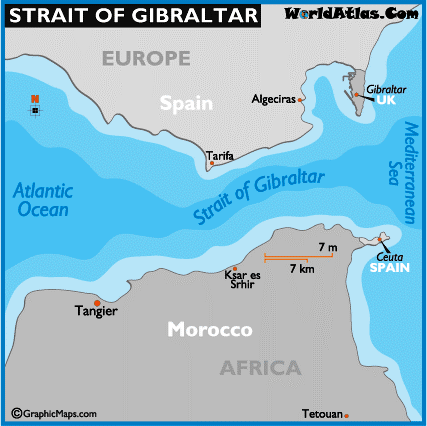
The Strait of Gibraltar connects
the Atlantic Ocean and the Mediterranean Sea, is about 60 kilometres long and
between 14 and 44 kilometres broad. The Strait of Gibraltar is the only natural
link between the Atlantic Ocean and the Mediterranean Sea and is one of the
busiest waterways in the world. Approximately 300 ships cross the Strait every
day, about one ship every 5 minutes.

On the northern side of the
Strait are Spain and Gibraltar (a British overseas territory in the Iberian
Peninsula), while on the southern side are Morocco and Ceuta (a Spanish
autonomous city in northern Africa). Its boundaries were known in antiquity as
the Pillars of Hercules. The narrowest point of the Strait is just off Tarifa (in
Spain), the southernmost city of mainland Europe, it is only 14 kilometres to
Mount Jbel Musa in Morocco, Africa. The Spanish side of the Strait is protected
under El Estrecho Natural Park.
2. A. 60
Degree (South)

The
Southern Ocean, also known as the Antarctic Ocean or the Austral Ocean,
comprises the southernmost waters of the World Ocean, generally taken to be
south of 60° S latitude and encircling Antarctica. As such, it is regarded as
the second-smallest of the five principal oceanic divisions: smaller than the
Pacific, Atlantic, and Indian Oceans but larger than the Arctic Ocean.


The International
Hydrographic Organization (IHO) included the ocean and its definition as the
waters south of the 60th parallel south in its 2002 revisions, but this has not
been formally adopted, due to continuing impasses about some of the content,
such as the naming dispute over the Sea of Japan.
3. B.
Mekong


The
Zambezi, the fourth-longest river in Africa is the largest river flowing into the Indian Ocean from Africa. Rising
in the black marshlands of Zambia, the river flows through eastern Angola,
along the north-eastern border of Namibia and the northern border of Botswana
then along the border between Zambia and Zimbabwe to Mozambique, where it
crosses the country to empty into the Indian Ocean. The Victoria Falls is the
most notable feature of the river.


The Murray River is Australia's longest river (2,508 kilometres in length) which rises in the Australian Alps, draining the western side of Australia's highest mountains and then meanders across Australia's inland plains, forming the border between the states of New South Wales and Victoria as it flows to the northwest into South Australia. It turns south at Morgan for its final 315 kms reaching the Indian Ocean at Lake Alexandrina.

Mekong River, the longest river in Southeast Asia, is a trans-boundary river having an estimated length of 4,350 km. From the Tibetan Plateau the river runs through China, Myanmar, Laos, Thailand, Cambodia and Vietnam where it empties into the South China Sea, a marginal sea of the Pacific Ocean.
4. C. Labrador Current

The Grand
Banks of Newfoundland are a series of underwater plateaus (these areas are
relatively shallow, ranging from 15 to 91 metres in depth) south-east of the
island of Newfoundland on the North American continental shelf. The cold
Labrador Current mixes with the warm waters of the Gulf Stream here, often
causing extreme foggy conditions. The mixing of these waters and the shape of
the ocean bottom lifts nutrients to the surface. These conditions helped to
create one of the richest fishing grounds in the world supporting fish species
including Atlantic cod, swordfish, haddock, capelin, shellfish and lobster. The
area also supports large colonies of seabirds such as northern gannets, shear
waters and sea ducks and various sea mammals such as seals, dolphins and
whales.
Overfishing in the late 20th century caused the collapse of
several species, particularly cod, leading to the closure of the Canadian Grand
Banks fishery in 1992.
5. A.
Iran

(Satellite image of the Caspian Sea)
Caspian
Sea, world’s largest inland body of water is variously classed as the world's
largest lake or a full-fledged sea. It lies to the east of the Caucasus
Mountains and to the west of the vast steppe of Central Asia. The sea’s name
derives from the ancient Kaspi peoples, who once lived in Transcaucasia to the
west.
It has a
salinity of approximately 1.2% (12 g/l), about a third of the salinity of most
seawater. The wide and endorheic Caspian Sea has a north–south orientation and
its main freshwater inflow, the Volga River, enters at the shallow north end.


(A mosque in Baku, Azerbaijan, near the shore of the Caspian
Sea)
It is
bounded by Kazakhstan to the northeast, Russia to the northwest, Azerbaijan to
the west, Iran to the south, and Turkmenistan to the southeast.


No comments:
Post a Comment