Showing posts with label Oceans. Show all posts

Monday, June 8, 2020

THE OCEANS AND THE SEAS - 2 - ANSWERS


1. A. Strait of Hormuz


The Strait of Hormuz is a strait between the Persian Gulf and the Gulf of Oman. It provides the only sea passage from the Persian Gulf to the open ocean and is one of the world's most strategically important choke points. On the north coast lies Iran and on the south coast the United Arab Emirates and "Musandam", an exclave of Oman. The strait is about 167 km long, with a width varying from about 96 km to 39 km.


A third of the world's liquefied natural gas and almost 25% of total global oil consumption passes through the strait, making it a highly important strategic location for international trade.


1. C. White Sea


(Location of White Sea, Red Sea, Black Sea and Yellow Sea - coloured as per their name)


The White Sea is one of four seas named in English after common color terms — the others being the Black Sea, the Red Sea and the Yellow Sea. All the above four seas are located in the Northern Hemisphere and the White Sea is located at the highest latitude (i.e. farthest from the Equator) as an almost landlocked extension of the Arctic Ocean indenting the shores of northwestern Russia connected to the more northerly Barents Sea by a long, narrow strait at 65 Degree North latitude in comparison to the Black Sea (44 Degree North), the Red Sea (22 Degree North) and the Yellow Sea (35 Degree North).


3. C. Sunda Strait


"Krakatoa" (Krakatau) is a small volcanic island located in the Sunda Strait which connects the Java Sea to the Indian Ocean, between the islands of Java and Sumatra. At the time of its famous eruption in 1883, the region was part of the Dutch East Indies; it’s now part of Indonesia.


A previous major eruption, likely in the fifth or sixth century A.D., is thought to have created Krakatoa and two nearby islands, "Lang" and "Verlatan", as well as the undersea caldera (volcanic crater) between them. By 1883, Krakatoa was made up of three peaks: "Perboewatan", the northernmost and most active; "Danan" in the middle; and the largest, "Rakata", which formed the southern end of the island.


Krakatoa was last thought to have erupted some two centuries earlier, in 1680, and most people believed it was extinct. But in May 1883, people reported feeling tremors and hearing explosions, first in western Java and then on the other side of the Sunda Strait in Sumatra.


(An 1888 lithograph of the 1883 eruption of Krakatoa)


Around 1 p.m. on August 26, 1883 a volcanic blast sent a cloud of gas and debris some 15 miles into the air. It would be the first in a series of increasingly powerful explosions over the next 21 hours, culminating in a gigantic blast around 10 am on August 27 that propelled ash some 50 miles into the air and could be heard as far away as Perth, Australia (a distance of some 4500 kms). About 9 square miles of the island, including both "Perboewatan" and "Danan" peaks of the island, plunged underwater into the caldera ("a large cauldron-like hollow that forms shortly after the emptying of a magma chamber/reservoir in a volcanic eruption") to a depth of some 820 feet below sea level. Krakatoa’s violent eruption killed more than 36,000 people.


(The approximate extent to which the Krakatoa eruption blasts were heard)


In 1927, a fourth island, Anak Krakatau, or "Child of Krakatoa", emerged from the caldera formed in 1883. There has been new eruptive activity in the island since the late 20th century, with a large collapse causing a deadly tsunami in December 2018. Like all volcanic eruptions, Krakatoa’s can be traced to the movement of the tectonic plates that make up the Earth’s crust. Krakatoa is directly above the subduction zone of the Eurasian Plate and the Indo-Australian Plate where the plate boundaries make a sharp change of direction, possibly resulting in an unusually weak crust in the region.


(The Subduction Zone of the Eurasian Plate and the Indo-Australian Plate near Krakatoa, Indonesia)


Indonesia today has over 130 active volcanoes, the most of any nation.


4. C. Sargasso Sea


The Sargasso Sea is a region of the Atlantic Ocean bounded by four currents forming an ocean gyre. Unlike all other regions called seas, it has no land boundaries.


It is distinguished from other parts of the Atlantic Ocean by its characteristic brown Sargassum seaweed and often calm blue water. While there are many different types of algae found floating in the ocean all around world, the Sargasso Sea is unique in that it harbors species of sargassum that are 'holopelagi' - this means that the algae not only freely floats around the ocean, but it reproduces vegetatively on the high seas. Other seaweeds reproduce and begin life on the floor of the ocean. Sargassum provides a home to an amazing variety of marine species. Turtles use sargassum mats as nurseries where hatchlings have food and shelter. Sargassum also provides essential habitat for shrimp, crab, fish and other marine species that have adapted specifically to this floating algae.


The sea is bounded on the west by the Gulf Stream, on the north by the North Atlantic Current, on the east by the Canary Current, and on the south by the North Atlantic Equatorial Current, a clockwise-circulating system of ocean currents termed the "North Atlantic Gyre". It lies between 70° and 40° W longitude and 20° to 35° N latitude and is approximately 1,100 km wide and 3,200 km long. Bermuda is near the western fringes of the sea.


5. B. North Sea


North Sea, the northeastern arm of the Atlantic Ocean, is located between the British Isles (England and Scotland) and the mainland of northwestern Europe and covering an area of 220,000 square miles. An inland sea on the European continental shelf, it connects to the Atlantic Ocean through the English Channel in the south and to the Arctic Ocean through the Norwegian Sea in the north.


("Dogger Bank", one of the major fishing zones in the world is located in a shallow area of the North Sea at about 100 kilometres off the east coast of England)


The North Sea has long been the site of important European shipping lanes as well as a major fishery. The coast is a popular destination for recreation and tourism in bordering countries, and more recently the sea has developed into a rich source of energy resources, including fossil fuels, wind, and early efforts in wave power.

(A map from Ptolemy's Geography showing the "Oceanus Germanicus" - "German Ocean")


Historically, the North Sea has featured prominently in geopolitical and military affairs, particularly in Northern Europe. It was also important globally through the power northern Europeans projected worldwide during much of the Middle Ages and into the modern era. The North Sea was the centre of the Vikings' rise. As Germany's only outlet to the ocean, the North Sea continued to be strategically important through both World Wars.


(Edmond Halley's solar eclipse 1715 map showing "The German Sea")


Until the late 19th century, the North Sea has been mentioned as the "German Ocean" or "German Sea" in many important maps (including the map from Ptolemy's "Geography" and Edmond Halley's solar eclipse 1715 map).


Sunday, June 7, 2020

THE OCEANS AND THE SEAS - 2


Q1. Name this narrow strait between the Persian Gulf and the Gulf of Oman which provides the only sea passage from the Persian Gulf to the open sea.


A. Strait of Hormuz

B. Mesina Strait

C. Bab-el-Mandeb


Q2. Which one of these seas is located at the farthest from the Equator?


A. Black Sea

B. Red Sea

C. White Sea


Q3. “The Island of Krakatoa”, where one of the most deadly volcanic eruptions of modern history occurred in August 1883 is located in __________ .


A. Duncan Passage

B. Strait of Malacca

C. Sunda Strait


Q4. Which one among the following seas has no land boundaries?


A. Philippine Sea

B. Bering Sea

C. Sargasso Sea


Q5. Mentioned as the "German Ocean" or "German Sea" in many maps until the late 19th century, which water body separates a major part of the United Kingdom from mainland Europe?


A. Celtic Sea 

B. North Sea

C. Irminger Sea


Saturday, June 6, 2020

THE OCEANS AND THE SEAS - 1 - ANSWERS


1. C. Ferdinand Magellan


In 1519, Portuguese navigator Ferdinand Magellan, in the employ of Spain, began a journey across the Atlantic Ocean to seek a western route to the Spice Islands via South America.


(The Strait of Magellan)


After braving perilous seas and navigating through what is now known as the "Strait of Magellan" (a navigable sea route in southern Chile separating mainland South America to the north and Tierra del Fuego to the south), his small fleet entered an unfamiliar ocean in November, 1520. He called this body of water “Mar Pacifico" which means “peaceful sea” in Portuguese, due to the calmness of the water at the time.


(The Voyage of Magellan)


("Victoria", the sole ship of Magellan's fleet to complete the circumnavigation)


When Magellan and his crew entered the Pacific Ocean (“Mar Pacifico") after their long journey, they thought that the Spice Islands were close at hand. Little did they know that their destination remained thousands of miles away. The explorers had ventured into the largest ocean on Earth.


2. B. Gulf of Aden


The Gulf of Aden is a deep water gulf which separates the Arabian peninsula from the Horn of Africa. It is located to the south of Yemen and to the north of Somalia.


The Gulf of Aden is integral to the world economy as the delivery of a major portion of the Persian Gulf oil takes place through this water body. The waterway is also part of the important Suez Canal shipping route between the Mediterranean Sea and the Arabian Sea in the Indian Ocean, with about 21,000 ships crossing the gulf annually.


The rise of pirates in Gulf of Aden can be attributed to the political development in Somalia in the 1990s. After the collapse of the Somali government in 1991 with the onset of Somali Civil War and the disbandment of the Somali Navy, international fishing vessels began to conduct illegal fishing in Somali territorial waters. This depleted local fish stocks and Somali Fishing communities responded by forming armed groups to deter the invaders. These groups, using small boats, would sometimes hold vessels and crew for ransom. This grew into a lucrative trade, with large ransom payments. The pirates then began hijacking commercial vessels. In the early 2000s, the incidents of piracy increased and the Gulf of Eden evolved into a hub of pirate activity earning the dubious sobriquet "Pirates' Alley". However, since 2013 attacks in the waters had steadily declined due to active private security and international navy patrols.


3. B. Tasman Sea


The Tasman Sea is a marginal sea of the South Pacific Ocean, situated between Australia and New Zealand measuring about 2,000 km across and about 2,800 km from north to south. The sea was named after the Dutch explorer "Abel Janszoon Tasman", who was the first recorded European to encounter New Zealand and Tasmania.


The Tasman Sea is informally referred to in both Australian and New Zealand English as "the Ditch"; for example, crossing "the Ditch" means travelling to Australia from New Zealand, or vice versa. The diminutive term "the Ditch" used for the Tasman Sea is comparable to referring to the North Atlantic Ocean as "the Pond".


4. A. Cape Town


The Port of Cape Town is situated in Table Bay (named after the iconic flat-topped Table Mountain located in Cape Town), a natural bay on the Atlantic Ocean.


Because of its position along one of the world's busiest trade routes the Port of Cape Town is one of the busiest ports in South Africa, handling the largest amount of fresh fruit and second only to Durban as a container port. The port also has significant repair and maintenance facilities that are used by several large fishing fleets and parts of the West African oil industry. Because of the many tourist attractions offered by Cape Town and its surrounding region, many cruise ships also berth in the port.


(Major Ports of Africa)


The Port of Mombasa (Kilindini Harbour) is located in the Indian Ocean while the Port of San Francisco is situated in the Pacific Ocean. 


5. A. Melanesia


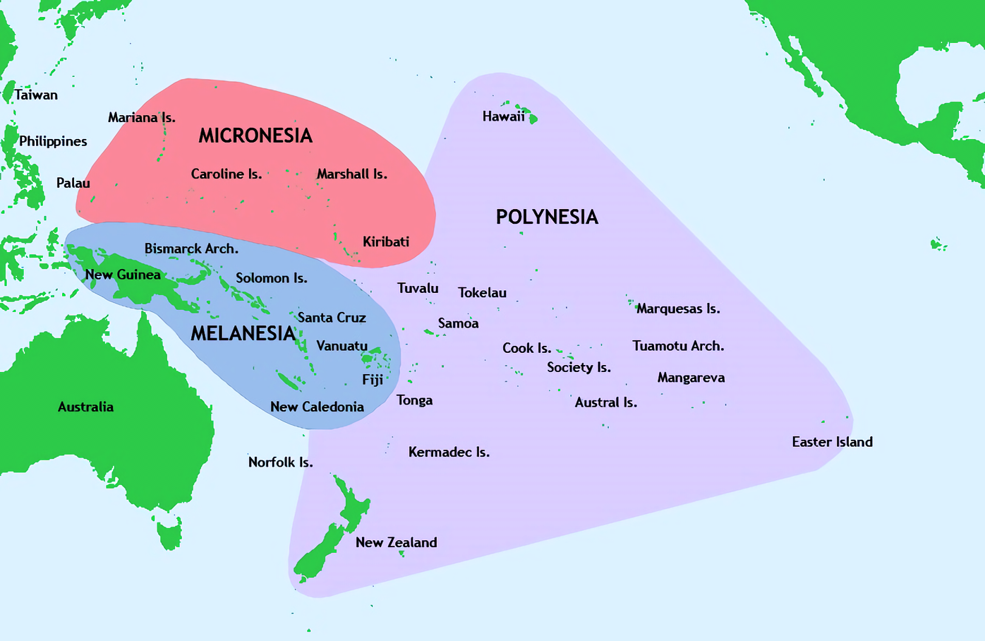
Melanesia is a sub-region of Oceania extending from New Guinea island in the southwestern Pacific Ocean to the Arafura Sea and eastward to Tonga.


The region includes the four independent countries of "Fiji", "Vanuatu", "Solomon Islands", "Papua New Guinea" as well as the French special collectivity of "New Caledonia", and parts of Indonesia – particularly Western New Guinea.


The name "Melanesia" was first used by Jules Dumont d'Urville in 1832 to denote an ethnic and geographical grouping of islands whose inhabitants he thought were distinct from those of Micronesia and Polynesia - the other sub-regions of the Oceania. The name "Melanesia" etymologically means "islands of black [people]", in reference to the dark skin of the inhabitants.


Oceania is a geographic region (not a Continent because its landmasses do not lie on the same area of continental crust), which consists of Australia and the three main Pacific island groups (Micronesia, Melanesia and Polynesia). Oceania is the collective name for the islands scattered throughout most of the Pacific Ocean. The term, in its widest sense, embraces the entire insular region between Asia and the Americas.


Broadly, Oceania is a distinct region because it has an ecology different from Asia, is historically a political region distinct from Asia, and has its position across the Pacific Ocean as a unifying geographic feature. The most popular usage delimits Oceania further by eliminating Indonesia, Taiwan and the Philippines, because the people and cultures of those islands are historically more closely related  to the Asian mainland.


Friday, June 5, 2020

THE OCEANS AND THE SEAS - 1


Q1. Who gave the Pacific Ocean its current name in 1520 when he experienced favorable winds upon reaching the ocean and named it “Mar Pacifico” which means “peaceful sea” in Portuguese?


A. Christopher Columbus

B. Francis Drake

C. Ferdinand Magellan


Q2. Which of the following water bodies is referred as "Pirates' Alley" because of increased number of pirate activities in the region in the early 2000s?


A. Gulf of Mexico

B. Gulf of Aden

C. Gulf of Guinea


Q3. Identify the Sea (blue-coloured) in the map below.


A. Coral Sea

B. Tasman Sea

C. Arafura Sea


Q4. Which one among the following Port Cities is located on Atlantic Ocean?


A. Cape Town

B. Mombasa

C. San Francisco


Q5. Which region of Oceania consisting of Vanuatu and the Solomon Islands, etymologically means "Islands of Black People" referring to the skin color of the inhabitants?


A. Melanesia

B. Peloponesia

C. Polynesia


INDIA AT THE CRICKET WORLD CUP

INDIA AT THE CRICKET WORLD CUP - 5 - ANSWERS

  1. C. Krishnamachari Srikkanth   (BBC TV's Peter West with the two captains - Clive Lloyd and Kapil Dev before the toss) The India...